| About Us |
| News |
| Announcement |
| Research |
| Conservation & Horticulture |
| Public Education |
| Graduate Study |
| Scientist |
| International Cooperation |
| Resources |
| Annual Reports |
| Publications & Papers |
| Visit XTBG |
| Societies |
| XTBG Seminar |
| Open Positions |
| 4th XSBN Symposium |
| CAS-SEABRI |
| PFS-Tropical Asia |
| Links |
| Location:Home > News > News Updates |
| The Echoes of Ecological Secrets of Mount Qomolangma from Ancient Times |
|
SU Tao Xishuangbanna Tropical Botanical Garden (XTBG), Chinese Academy of Sciences
The majestic Mount Qomolangma is the Earth’s highest peak at 8,848 meters above sea level. Located in the Himalaya, it straddles the China-Nepal border. This mighty mountain holds many secrets about the geological history and environmental changes of the Qinghai-Tibetan Plateau. In April 2022, Chinese scientists launched a large-scale comprehensive scientific investigation in the Mount Qomolangma region, called the “Earth Summit Mission”. Herein, I am very pleased to recount what occurred to our team’s paleontological field investigation during this scientific endeavor and the one before it.
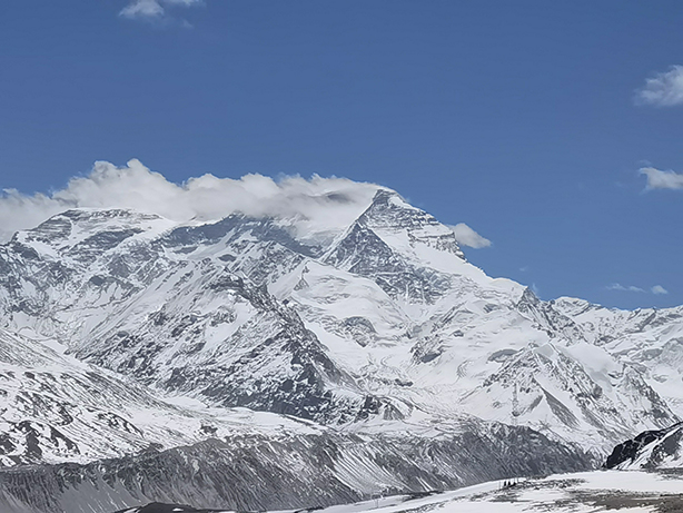
Reconstruction of the biota in central Tibetan region from about 47 million years ago. (Artwork by Alex Boersma) The first comprehensive scientific expedition to the Qinghai-Tibetan Plateau (hereafter referred to as the “First Expedition”) was a large-scale and extremely difficult field scientific expedition organized by assembling the forces of scientific researchers across China. The First Expedition, which lasts 20 years from 1973 to 1993, aimed to conduct comprehensive scientific surveys of the Plateau. This expedition yielded fruitful results. For examples, the discovery of ophiolite revealed the existence of five suture zones on the Plateau, proving that the plateau was formed by the accretion of different terranes; the discoveries of alpine oak leaf fossils on Mount Shisha Pangma and three-toed horse fossils in Gyirong opened a new chapter for Chinese researchers to use paleontological fossils to understand the uplift history of the Plateau. Initiated in 2017, the second comprehensive scientific expedition to the Plateau (hereafter referred to as the “Second Expedition”) was a continuation and further study of the First Expedition, aiming to mechanistically interpret the changes of the Plateau. With the vigorous implementation of the Second Expedition, scientific investigations of some key areas of the Qinghai-Tibetan Plateau were put on the agenda, including the Mount Qomolangma region located in the middle part of the Himalaya. In April 2022, the Institute of Tibetan Plateau Research (ITP) of the Chinese Academy of Sciences (CAS) took the lead in launching the “Earth Summit Mission”, a large-scale comprehensive scientific investigation in the Mount Qomolangma region. This mission brought together 16 scientific investigation teams in various research fields, including glaciers, atmosphere, hydrology, and paleontology, with over 200 scientific researchers from many institutions and universities. To obtain continuous scientific observation data and more research materials, the Earth Summit Mission was extended to 2023. Our team, the Paleoecology Group, Xishuangbanna Tropical Botanical Garden (XTBG) under the CAS, was honored to participate in this scientific investigation and jointly carried out paleontological field investigations for half a month with colleagues from the Institute of Vertebrate Paleontology and Paleoanthropology (IVPP) under the CAS. During this expedition, we revisited the fossil site in Gagbala on Mount Cho Oyu that was reported during the First Expedition and climbed Mount Qomolangma to an altitude of 6,500 meters. It was an unforgettable scientific investigation that also set a new high-altitude record for our team’s fieldwork on the Plateau. Fossils witness tremendous changes of the Mount Qomolangma region. About 60 million years ago, the Indian Plate from the Gondwana supercontinent collided with the Eurasian Plate, leading to the gradual closure and retreat of Neo-Tethys Ocean and the formation of the highest and most spectacular mountain range on the Earth – the Himalaya. On the summit of Mount Qomolangma, there is a 460-million-year-old Ordovician marine deposit, yielding marine organisms such as brachiopods, goniatites and sea lilies. Until the Triassic and Cretaceous Periods, the Mount Qomolangma region was still dominated by marine sediments. In Nyalam County, fossils of large ichthyosaurs from the Late Triassic have been discovered. In Jixiong Village, Tingri County, numerous exquisitely preserved Jurassic ammonites have been found. It was not until 15 million years ago that the elevation of the Himalayas reached 4,500 meters above sea level. The discovery of alpine oak leaf fossils from Mount Shisha Pangma near the Dasuopu Glacier at an altitude of about 6,000 meters shows that forests once grew in the current frigid middle Himalaya. The above discoveries were important achievements during the First Expedition. However, due to the extreme altitude, low oxygen and harsh climate in the Mount Qomolangma region, fieldwork was extremely difficult. Subsequently, there had been no follow-up investigation and research for these fossil sites since then. To further understand the paleoenvironmental significance of this flora, it is necessary to continue field investigations of these fossil sites, discover new fossil specimens, and carry out comprehensive research combining traditional methods and new technologies and theories. Mount Cho Oyu, with an altitude of 8,201 meters, ranks 6th among the 14 peaks above 8,000 meters in the world. It is located about 28 kilometers west of Mount Qomolangma, facing Mount Qomolangma from afar.
Mount Cho Oyu. (Image by XTBG) The First Expedition discovered and reported spruce cone fossils at an altitude of ~5,000 meters in a place called Gagbala on Mount Cho Oyu. One of the main tasks of our field investigation this time was to find the fossil site in Gagbala and collect fossil specimens. On the first day we arrived at Mount Cho Oyu, we came to Gagbala, but due to intense glacial activity, the land surface was covered with a large amount of moraine, without any fossil. So, we went to nearby Rongxar Valley to investigate the modern vertical vegetation zones on the southern slope of the Himalaya.
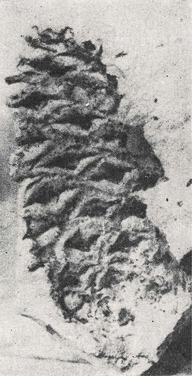
A photo of Himalayan spruce cone fossil, which was discovered at the fossil site of Gagbala on Mount Cho Oyu during the First Expedition. (Credit: CAS) After crossing the Bozila pass, we descended to the Rongxar Valley. Rhododendrons and willows were densely distributed on both sides of the valley, while spruce forests grew at slightly lower elevations of the valley, followed by birch, fir and Himalayan oak forests. Although not as famous as the Himalaya’s five valleys, namely the Gyirong Valley, Zhangmu Valley, Gama Valley, Yadong Valley and Chentang Valley, one can reach this lush forest in less than two hours’ drive from Gangga Town (4,300 meters above sea level) to the Rongxar Valley. Here, you can experience natural landscapes completely different from the frigid Plateau, with vertical vegetation zones condensed along the steep mountainside. The northern slope of the Himalaya must have been like this vegetational landscape tens of millions of years ago. On our way back to the base at Gangga Town, we decided to take another look at our last selected stratigraphic section in Gagbala. By that time, it was getting dark, and gale-force winds carrying ice pellets hit us head-on. We climbed to a position near the top of the section and finally found the long-awaited plant fossils in a layer of light-yellow sandstones. Early the next morning, we came to the fossil site to conduct a systematic excavation. Angiosperm leaves, aquatic plant fossils were constantly being unearthed, and fish fin rays were found at this fossil site for the first time. The combination of these fossils formed a stark contrast to the current bleak and frigid environment, intuitively demonstrating that the middle Himalaya used to be much warmer and more humid than today.
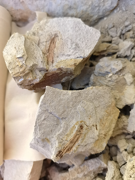
Fossilized fin rays of ancient fish were discovered at a site in Gagbala. (Image by XTBG)
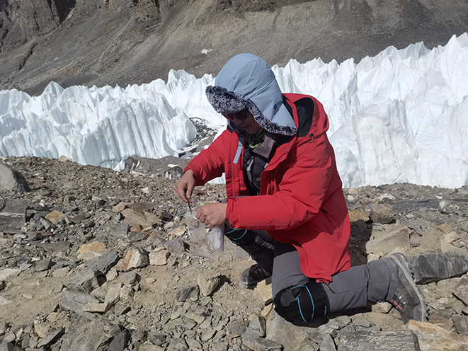
Plant fossils found in a layer of light-yellow sandstones at a site in Gagbala. (Image by XTBG) To comprehensively study these fossil materials, it is necessary first to determine their geological age. Currently, there are two main methods. One is to determine the relative geological age of the strata based on characteristic fossil groups. For example, the evolutionary rates of some rodent mammals are very fast, with specific groups appearing in different periods. Additionally, C4 plants – plants that have evolved a sort of “turbo-charged” form of photosynthesis, such as maize, sorghum, and sugarcane – began to expand globally in the late Miocene. However, biostratigraphy, or the stratigraphic frame of biological fossils, with limited accuracy, can only cue a time range of geological ages. To determine the absolute age of a stratum, it is necessary to use long-lived radioactive isotopes in igneous minerals for dating. After determining the age of a certain stratigraphic horizon through the above methods, magnetostratigraphy (a method that uses the magnetic signals preserved in rocks to figure out the relative ages of rock layers) or cyclostratigraphy (a method for dating rock layers based on the idea of cyclic sedimentary patterns) can be used to establish a complete time sequence for the strata, thus providing a time framework for biological evolution and environmental events. Biostratigraphy requires characteristic fossils with chronological significance, while magnetostratigraphy relies on igneous rocks. Therefore, looking for various chronological materials was also a focus of our investigation this time. Regrettably, none was found, and more work at this fossil site is needed in the future. Yes, Mount Cho Oyu, we will come back again! On the contrary, plant fossils were abundant in Gagbala. After collecting for half a day, we obtained nearly 100 plant fossil specimens and returned. Identifying these fossils and revealing their paleoenvironmental significance still requires a lot of work in the lab. In recent decades, besides traditional morphological comparison of fossils, some new methods have also been applied to paleobotanical research, such as MicroCT scanning that can non-destructively and accurately observe the three-dimensional morphology and internal structure of fossils; fluorescence microscopy can provide more detail on the morphology of fossil surface. In recent years, the use of paleoenvironmental values obtained from biological fossils has provided important boundary conditions for model simulations, and hence has allowed us to decipher the evolutionary history of biodiversity and environmental changes in the Plateau, temporally and spatially in larger scales. For example, our team recently discovered palm fossils in the Lunpola basin in the central part of the Plateau. By comparing the climate requirements of the natural distribution areas of extant palm species with paleoclimate model simulations under different topographic scenarios, we found that there may exist a central valley no higher than 2,700 meters in the Plateau 39 million years ago. Additionally, the drone has also provided a broader perspective for field investigation of strata; meanwhile, it can quickly reach the target outcrop to take high-resolution images, thus better locating the target area for fieldwork. After successfully completing the field investigation at Mount Cho Oyu, we went to Mount Qomolangma to collect modern pollen samples along an altitudinal gradient. Pollen refers to the spores or pollen of plants. Pollen grains are usually no more than 100 microns in size, produced in extremely large quantities and widely distributed in soils of modern land surface. Due to the strong resistance of pollen walls to weathering, they can be preserved in strata for a long time and are quite abundant. They are one of the main materials for paleobotanical research. As far as we know, no team has yet collected soil samples from the extremely high altitude of Mount Qomolangma so far. Our collected samples will help recognize the characteristic pollen assemblages of the extreme high-altitude areas, and further improve the modern pollen spatial distribution database (under construction by our team) across the Plateau. By comparing pollen assemblages in strata with modern pollen databases, we can reconstruct the vegetation and paleoenvironment of the Plateau during different geological periods.
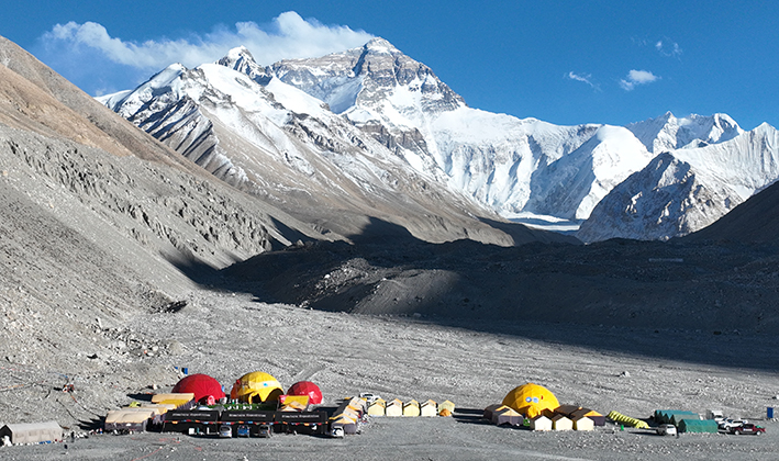
Collecting soil samples on Mount Qomolangma. (Image by XTBG) On the afternoon of May 10, we arrived at the Mount Qomolangma base camp at the altitude of 5,200 meters to prepare for the next day’s climb. By the time when we arrived, neat tents had been set up at the base camp as the headquarters and logistics base for the Earth Summit Mission. After sorting out all the climbing supplies, it was already late at night. At the night, a fierce gale assaulted the base camp. Although the tents had been reinforced, they were still swaying left and right. The mats we lay on swayed along with the shaking tent, just like a flat boat on the river. Fortunately, our “flatboat” remained safe and sound through the fierce winds of the night. On May 11, after breakfast, LIU Jia (my coworker at XTBG), WANG Wei (associate professor from IVPP) and I headed towards the 5,800-meter camp. Walking uphill along the rugged mountain road, we met some descending local porters and yak teams along the way. Due to intense glacial activity, the road to the summit of Mount Qomolangma is not fixed; and every year the mountaineers need to repair it in advance.
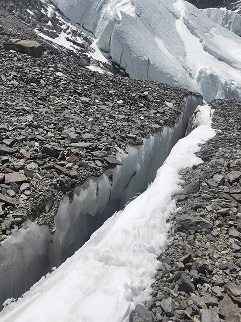
The base camp at the altitude of 5,200 meters on Mount Qomolangma. (Photo taken by HUANG Jian) At five pm, with the help of climbing guides, we arrived at the 5,800-meter camp. On the left side of the camp, a forest of gleaming white ice spires of the East Rongbuk glacier stood before our eyes, extending along the direction we would continue to move forward, and then turning around a corner to disappear behind the mountain. That night, we squeezed into a small tent. The sky was full of stars that seemed within our reach, with the purple Milky Way spanning across the sky, which was the most beautiful starry sky I ever lay eyes upon. The next morning, we continued to climb upwards along the East Rongbuk glacier, and after crossing over a long ridge, we came to the front of the ice spire forest of the East Rongbuk glacier. Each ice spire was at least 10 meters high, appearing particularly blue in the sun. After taking lunch by the ice spires, we continued towards the steep slope ahead. Along the way, we encountered many bottomless ice crevasses. Fortunately, they were just less than one meter wide, and could be jumped over.
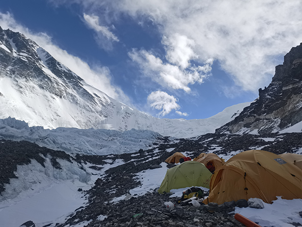
An ice crevasse we encountered on the way to the advance camp at an altitude of 6,500 meters. (Credit: XTBG) The advance camp at an altitude of 6,500 meters, known as the “devil camp”, was in a gulch in front of a big ice wall. The already thin oxygen level at this altitude was even further lowered in concentration due to the poor air circulation. Even experienced mountain climbers often get splitting headaches upon arriving here. When we reached the camp, some teammates were climbing the 300-meter vertical ice wall, beyond which was the camp at 7,080 meters. The “devil camp” really lived up to its name. The lack of oxygen made it difficult for everyone to fall asleep. Several oxygen cylinders became lifesavers, with everyone gathered together like fish stranded in a dried-up pond. On the morning of May 13, we reached the ice wall; without professional ice-climbing gears, we had to stop here. During the four days of climbing, we collected samples as scheduled from 5,200 to 6,500 meters in attitude, safely returned to the base camp, and successfully completed the scientific investigation mission this time.
A view of the advance camp, also known as “devil camp,” at an altitude of 6,500 meters on Mount Qomolangma. (Image by XTBG)
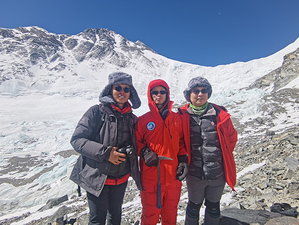
We were standing in front of the big ice wall near the “devil camp”. (Image by XTBG) In this “Earth Summit Mission”, there were some other scientific investigation teams battling at the extremely high altitudes of Mount Qomolangma. For example, the altitude of 6,500 meters where we halted this time was only the starting point for the glacier research team. Altitude sickness, avalanches, and ice crevasses could all lead to serious consequences at such extremely high altitudes on Mount Qomolangma. But the scientific expedition overcame all kinds of difficulties, camping on the glaciers, and devoted themselves to the scientific investigations. “Glacier research is a magnificent cause, and it is also the cause of the brave,” said SHI Yafeng, a late academician of the Chinese Academy of Sciences (CAS) who is regarded as the “Father of Chinese Glaciology”. Conducting scientific research on the Plateau requires courage. This is exactly the allure of the plateau – it holds so many natural mysteries that attract the curious to explore. Generation after generation of scientific expeditions to the Qinghai-Tibetan Plateau has forged ahead one after another, dedicating their own youth to this vast land, striving to scale new heights in science. URL: http://bcas.cas.cn/perspective/202308/t20230818_335101.html |

| Appendix Download |
|
|
